


A new assessment by the Greater Accra Resilient and Integrated Development (GARID) Project has revealed that about 16% of the legally designated 25-metre drainage buffer zones across selected assemblies in the Greater Accra Region have been encroached upon, raising concerns over worsening flood risks in the capital.
The findings were presented on Friday, July 3, by the GARID Project Coordinator and member of the Post-Flood Mitigation Committee, Kojo Ohene Safo, during a presentation on the state of drainage buffer zones in the region.
According to Mr. Ohene Safo, the assessment examined developments along waterways in 16 metropolitan, municipal and district assemblies, focusing on the mandatory 25-metre buffer zone on either side of drains, which is intended to keep waterways free of obstruction.
“With just this sample, we are seeing that of the 16 Assemblies that we did our analysis for just short sections, the count are 10,497 structures. And we have lost the buffers and this is just 25 metres of each side of the drain which the law requires to be kept free and clear of development.
“We have lost around 16% of the land and thereby leading to the situation we face,” he stated.
The study compared satellite and field data collected between 2022 and 2026 and found a steady increase in structures built within these protected corridors, despite planning regulations prohibiting such developments.
While Ablekuma Central recorded six structures within the buffer zone in 2022 with no additional encroachments during the latest assessment, Mr. Ohene Safo noted that the area was an exception.
Several other assemblies recorded significant increases in unauthorised developments.
In Ayawaso Central, the number of structures within the drainage buffer increased from 793 in 2022 to 801 in 2026. Ayawaso East recorded a sharper rise, climbing from 337 to 494 structures over the same period.
Ga Central also experienced continued encroachment, with 54 new structures added between 2023 and 2025, bringing the total number of structures within the assessed buffer zone to 2,329.
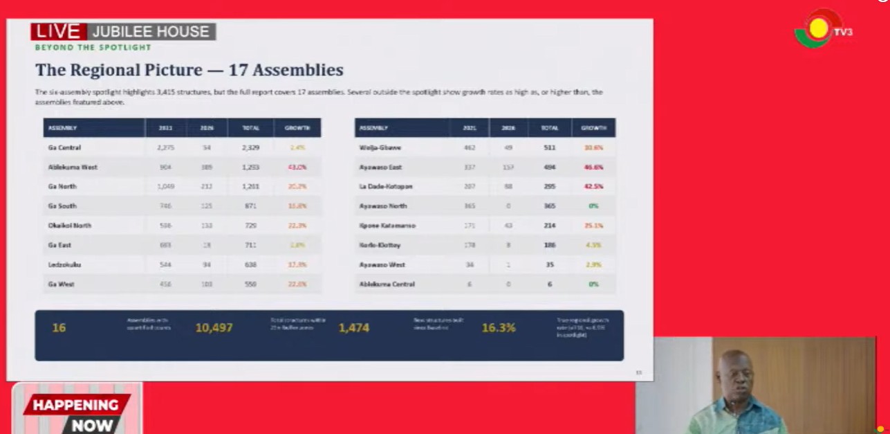
Other affected assemblies included Krowor, where structures increased from 178 to 295, Okai Koi North from 596 to 729, and Ablekuma West from 904 to 1,293.
Ga North recorded one of the most significant increases, with structures rising from 1,049 to 2,261, while Ga South saw an increase from 746 to 871.
The assessment also found continued encroachment in La Dade-Kotopon, where structures increased from 544 to 638, and in Adentan, which recorded an increase from 171 to 214.
Overall, the study identified 10,497 structures situated within designated drainage buffer zones across the sampled assemblies.
Mr. Ohene Safo warned that continued encroachment on waterways is reducing the capacity of drainage systems to carry stormwater, thereby increasing the likelihood of flooding during periods of heavy rainfall.
“And so, when we have the volume of rain that we do, the water doesn’t have a natural path. That will inevitably impact people; it will affect them,” he said.
The findings come amid renewed concerns over flooding in Accra following recent heavy rains, with authorities intensifying efforts to address illegal developments along waterways as part of broader flood mitigation measures.


